Origins of an Obelisk
Bredon's Grade II Listed Milestone
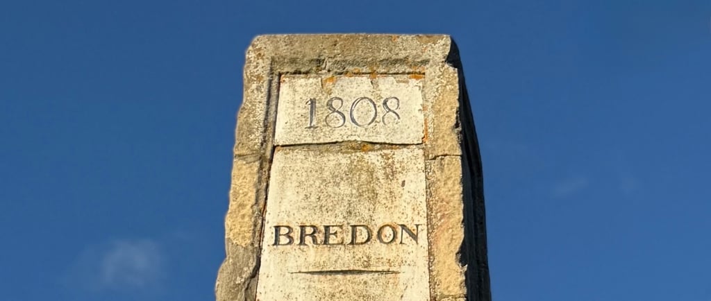
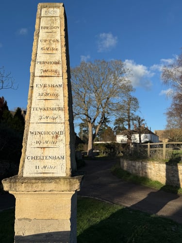
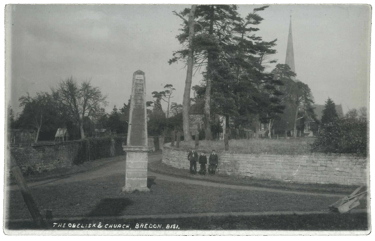
Echoing the spire of St Giles Church behind it, the obelisk-shaped Bredon Milestone stands at the head of Church Walk. The date inscribed at the top indicates that it was erected in 1808. Places & distances are listed on the inset cast iron plate, but unlike a guidepost or fingerpost there is no indication of direction.
I have found references suggesting that its construction might be connected to Tewkesbury Turnpike Trust, but nothing to confirm that yet. Indeed, the places marked on the signpost align with this theory as they match the roads managed by the trust, although the distances differ slightly to other sources.

In 1805 the Reverend John Keysall was instituted as the new Rector to Bredon. Born in January 1760 in Holborn, London, he remained Rector of Bredon over three decades, until his death 1836. His will details that during his time locally he invested in renovating old buildings & building new ones.
…and whereas during my incumbency as Rector of Bredon having expended large sums of money in erecting farm houses and buildings / occasioned by allotments of lands in lieu of tithes by virtue of Inclosure Acts and in making other substantial Improvements upon the Rectory House and Offices and the several farms and lands belonging to the said Rectory...
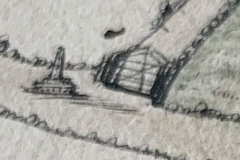
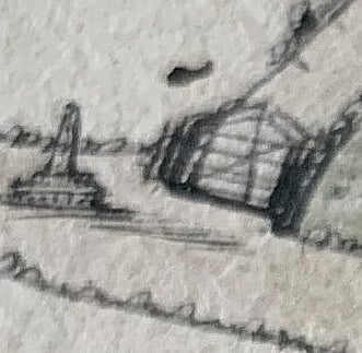
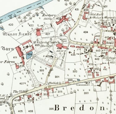
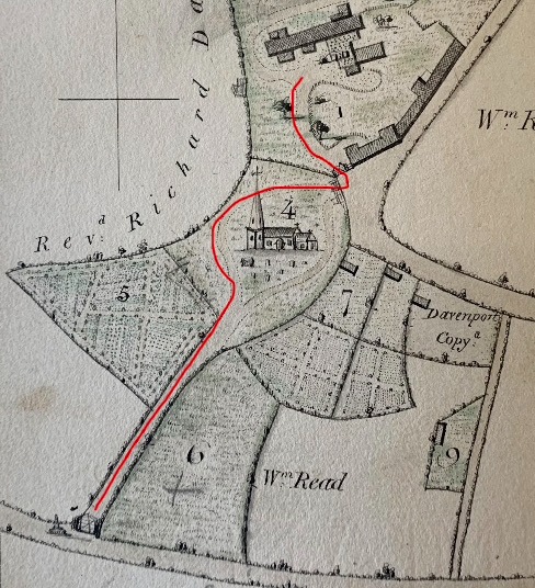
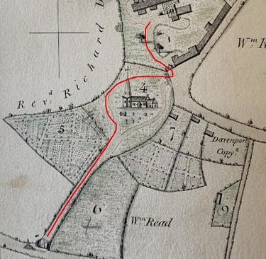
The earliest records of enclosure in the parish are from 1809 & the process was completed by 1811, which is the date of the award & plan. There is no tithe map for Bredon which makes the enclosure records a valuable source for local history. In between these two dates, in 1810, the Reverend Keysall also commissioned plans of his own estates in Bredon. The plans were surveyed and drawn by Samuel Joseph Harris. The leather bound book of original hand drawn plans remains extant in the holdings at Worcestershire Archive & is annotated with later notes in pencil, some of which show what happened to Rectory property & lands through the process of enclosure, recording names of occupiers, copyholders & owners in the parish during a period of particular flux. As part of this survey, the above small sketch of the obelisk appears in front of a gate (no longer there) at the head of Church Walk.
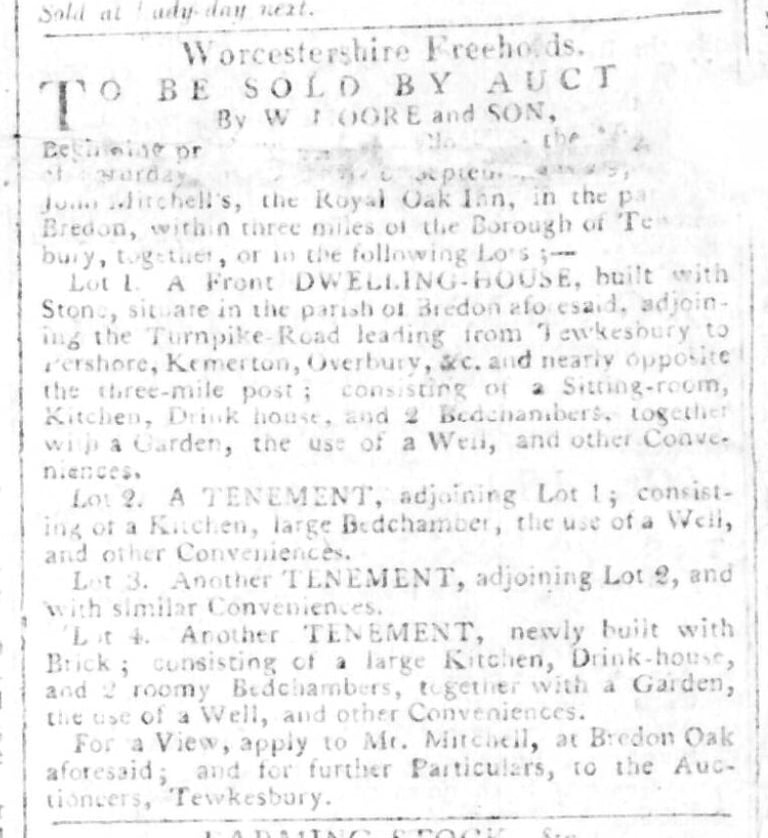
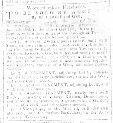
1809 is the earliest mention I have found of a mile marker here, in a faded sale advert for a dwelling-house nearly opposite, adjoining the turnpike road, and three adjoining tenements, though referred to as ‘the three-mile post’ as it is written from the perspective of a Tewkesbury auctioneer, which is three miles away.
The obelisk appears on several postcards over the years, a place marker near the landmarks of the old village, but it was this incidental sketch that first led me to think about it in more detail.
In the course of researching my own house I have discovered stories that relate to the history of Bredon: its people, places, houses, farms and landscape. Many extend to surrounding villages & towns, & over time, these fragments have begun to form a wider history of the area. This blog is the beginning of an attempt to weave a few of those threads together.

The rectory today is accessed via an entrance from Church Street, but a short description in the Enclosure Award of 1811 made me wonder if this obelisk marks more than the distances from Bredon to other places on the turnpike network. Bredon was a place where a number of turnpike roads met and branched off, but Church Walk is recorded in articles about enclosure from 1809, & in the award itself, as “the road leading to the Rectory House”. Certainly, having looked at other local turnpike milestones, Bredon’s seems designed to appear more impressive than a simple way marker.
The late Derrick Grainger, Headmaster of Bredon Hancock’s School until 1992 & excellent local historian, often recorded his memories on an online memories group:
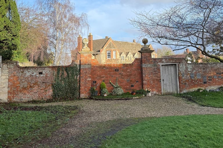
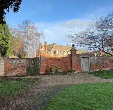
The building (Monk’s Close) together with the Church Room is formed from the stables, tack room, coach house and stableboys’ accommodation for the Rectory. Originally the blocked up arch in the centre was the entrance to the Rectory from Church Street. A second coach entrance was from the main Bredon-Tewkesbury Road at the Obelisk, up Church walk, around the west side of the church to a gateway in the churchyard wall, now blocked up.
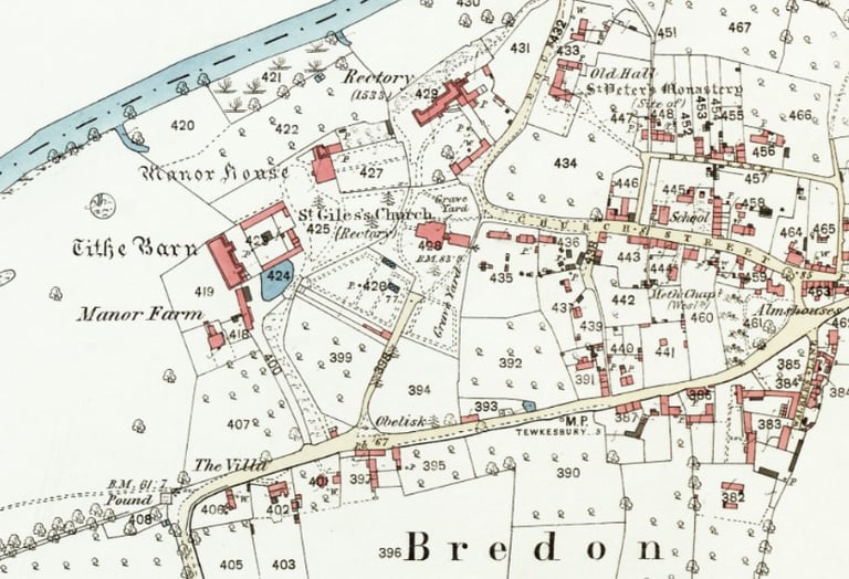
The gateposts remain in situ in the wall, however on looking back at older maps this entrance is not illustrated. The fact that the 1811 Enclosure Plan (not shown here) neither shows the obelisk nor gateway is inconclusive, however, it does show a gap which perhaps references the arch mentioned above. This gap does not appear on the survey completed for the Rector in 1810, & neither does the gateway in the wall. However a gate is drawn in where today's entrance is situated. As this was made specifically to record the Rector’s lands in 1810, it suggests that it is possible the "short-cut" was a later addition. The fact that it doesn't quite match up to the Enclosure Plan even though the dates align so closely is intriguing too, & perhaps supports a theory I have that the map used is of an earlier date but was reused for demarcating enclosure.
Either way, one entrance to the Rectory was via Church Walk & the churchyard. It would also take you to the main street in the village, or Church Street & in the time before coaches would this also have been a useful way to cut the corner via Dock Lane to the Eckington Road or Bredon’s Norton? You can still see path & trackways on satellite images.
This was the time of Turnpike Trusts, set up by individual Acts of Parliament to build and maintain roads across Britain. Several Stops & Turnpikes had first been petitioned for in Bredon as part of the Tewkesbury Turnpike Trust in January 1721 but never materialised, it is recorded that the roads were so poor in places that people gave money to local farmers to pass over private ground. By 1725 there was a debate about which roads the payment of tolls locally was paying to improve, & growing opposition to the scheme. Local residents complained that the journey from Bredon to Tewkesbury was ‘a good hard way’ & they complained that a gate should not be erected on the pretence of repairing it when the road being paid for via their tolls was miles away. Add to that the stone which was to be quarried from Bredon Hill for this network of improved roads would all pass over this route & likely cause it further damage in its journey to improve roads that the locals were unlikely to use. It was obviously, as change of this kind so often is, contentious.
There were eventually turnpikes, or gates set up that only opened once a toll was paid. The gates were positioned at carefully chosen spots where it was difficult to avoid paying, such as bridges or narrow sections of road shaped naturally by the landscape. Chains Corner may have originally been such a place; as well as a tollhouse & gate mentioned in the village (one was at the Eckington Road junction by the 1830s) there is a "Bredon Chain" referred to in an auction listing for Turnpike Tolls in 1864.
Upton 6 Miles | Pershore 7 Miles | EVESHAM 12 Miles
TEWKESBURY 3 MILES | winchcomb 10 mILES | cheltenham 11 mILES
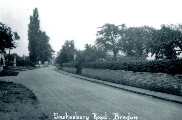
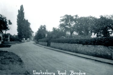
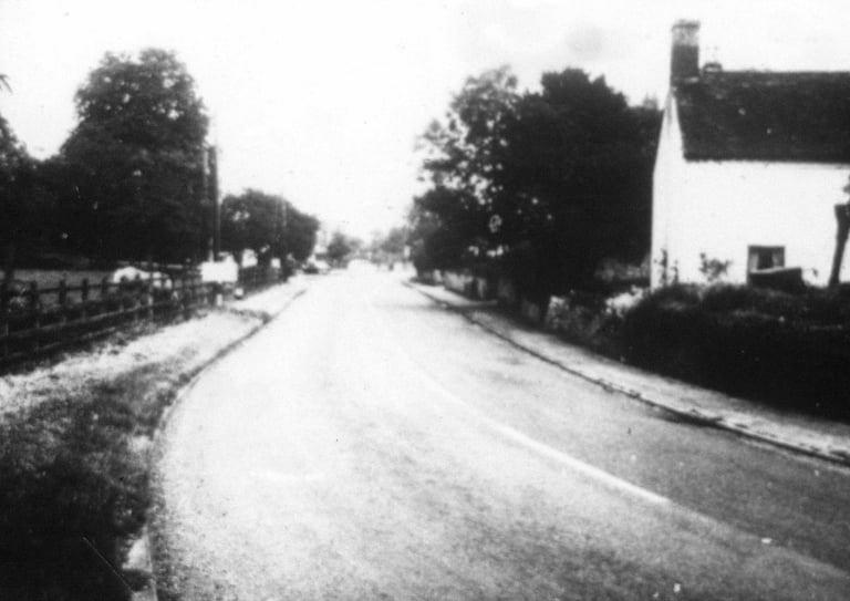
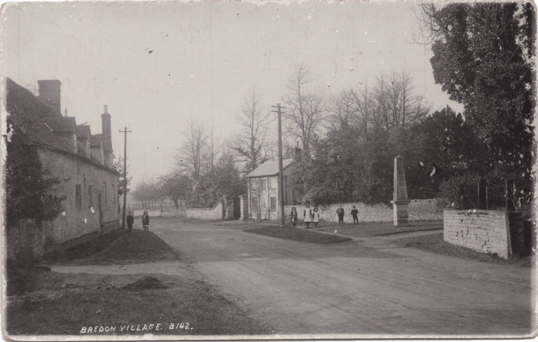
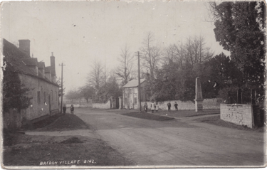
Chains Corner, which you would be standing at if taking the photograph above, is often incorrectly spelt as Cheynes. The house known as "Cheynes" House (not visible in the above photographs) was only named as such between 1951-1964, having originally been called Holly Bank. Visible after the third turning in the left is the obelisk. The first left hand turning is to Manor Farm & Bredon Barn & the second is a later addition as a separate entrance to the Manor House, which originally would have been via the first turning, as shown on the enclosure plan.
In a bid to pass his knowledge of this confusion on, Derrick Grainger wrote that: Prior to movement of cattle and other farm stock by lorry, all stock was driven to different pastures or to and from Tewkesbury Market, not just Bredon farmstock, but from the other hill villages as well. The sharp corner presented great danger to pedestrians of being trampled to death by cattle in the days when those who could not afford a horse went to and fro by “shanks’ pony”. So, probably in the early 1800s, a fence of CHAINS was erected so that pedestrians could use a pathway on the far side, and the hordes of cattle were guided round the corner.
It is possible that this may have been earlier than the early 1800s, not only because of the sharp bend in the turnpike road, but also as this corner was the location of the village pound, which presumably had been in use from much earlier, unless it had been relocated here.
Derrick continues: The chains were removed during the First World War as scrap “to aid the war effort.” [Remnants of railings and boot scrapers also remain around the church & houses on Church Street.] They were not replaced after the war as the wartime development in lorry design produced cattle lorries and stock movement on the hoof declined sharply. This information was passed to me and others by the late Harold Parker who, in his eighties was still an active member of Parish Council when I first joined. He was fiercely defensive of the correct spelling of the name as he as a younger man had lived through the days when the chains were in situ.
The local Turnpike disputes rumbled on through the 1700s, peaking in the 1830s before the coming of the railways. Road surfaces remained in a bad state of repair, worsened by greater and more diverse types of use, & parish responsibility could not keep up with repairs. Turnpike Acts were supposed to provide the means for individual areas to raise money to build and maintain better roads and allow faster transport of people, mail and goods. However the creation, towards the end of the 1700s, of The Vale of Evesham Road Club must have had its origins in a dissatisfaction that the system wasn’t working at a local level. Although as David Ella notes in The Way to London – Vale of Evesham Roads, 1350-1880, (2020) Pub: The Vale of Evesham Historical Society magazine, Almoner’s Pen :
Their major activity does seem to have been as a gentlemen’s dining club. Their monthly three-and-a-half-hour lunch was held at different Inns around the Vale, including the Crown in Evesham. Lunch - including drink - cost five shillings at a time when daily farm labourers pay was one shilling. However, the club did have some valuable aims & achievements...
The Road Club was written about in: A General View of the Agriculture of the County of Worcester with Observations on the means of its improvement. As well as exerting their influence on road improvements, it appears that the members were instrumental in encouraging villages to display their names prominently at the entry to each village. Returning to the photograph above showing the turnings to Manor, Church & Rectory - this would certainly have been considered as the entrance to Bredon Village.
Bredon Manor House shares a wall with the Rectory House & churchyard, & the later gateway & lodge sit just ahead of the turning to Church Walk. Of the cottages & houses on the other side of the road they are all shown on the enclosure plan, so would have also been in situ when the obelisk was built.
Before Keysall's time, John Darke was Lord of the Manor from the c.1780s, & it also transpires that he was a founder member of the Vale of Evesham Road Club, which consisted of a group of men from the villages around Bredon Hill. It is therefore likely that Keysall's neighbour Richard Darke, John's son, became a later member of this same club. Did John Keysall also become a member on his arrival in the village in 1806? Bredon Rectory offered a very valuable living & it must have come with a certain status & level of influence locally. Perhaps this is fanciful, but could he & his neighbour together have set the name of the village in stone in their roles as members of the road club? I can't yet separate the Bredon Obelisk's origins from the Reverend John Keysall & his clear desire to make his mark on Bredon, but I can’t yet prove otherwise…
Historic England Listing
BREDON
1. 2301 Tewkesbury Road Obelisk SO 93 NW 17/111 11.2.65. II
2. 1808. Tapering 4 sided stone obelisk on pedestal with moulded cornice. One side inscribed as direction post giving distances to nearby towns.
National Grid Reference: SO 91950 36827